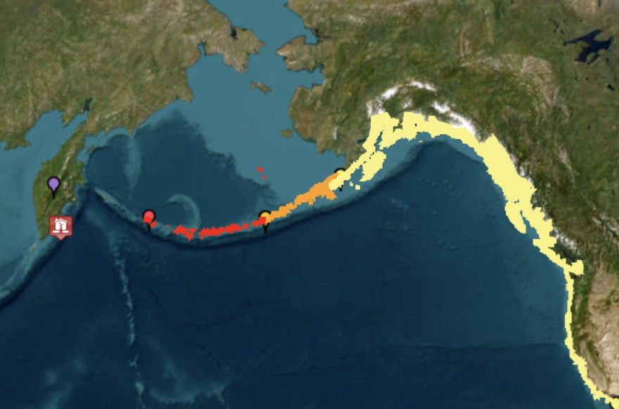
Tsunamis rippled across the Pacific Ocean after a massive magnitude 8.8 earthquake struck Tuesday afternoon off the coast of Russia’s Kamchatka Peninsula. The largest wave in Alaska was 2.7 feet and hit Adak Island Tuesday night, according to the Tsunami Warning Center. Despite the size of the earthquake, no major damage has been reported so far.
Dave Snider, Tsunami Warning Coordinator with the Tsunami Warning Center, joined Alaska Public Media's Casey Grove to talk about the science behind, and the risk of, tsunamis in Alaska.
Below is the transcript of an interview with Snider on Alaska News Nightly. It has been lightly edited for length and clarity.
Casey Grove: Dave, 8.8 is a pretty large earthquake, I guess one of the largest ever recorded. What was your initial reaction when you saw that number?
Dave Snider: Wow. Just wow. Like this is, this is what we practice for. This is what we exercise and develop for. And here we go.
CG: So how large were some of the bigger waves, and where did they occur?
DS: You know, for the United States, the largest waves, I believe, (were) still showing up from very early (Wednesday) morning around Crescent City, California, and their level wa around 4 feet, which was kind of in our warning forecast boundaries, I guess, for that part of the coastline there, northern Cal.
CG: Gotcha. And it kind of brings up another thing, too, and I'm hoping maybe you can walk me through the science of a tsunami wave and why the largest waves don't necessarily hit the communities closest to the epicenter of the earthquake, like we have heard now that the waves that hit in Alaska were somewhat smaller than the ones that hit Crescent City. Why is that?
DS: Well, if you put your hand on the table, you know, one of your fingers is going to be a little longer than the others. And every time an earthquake occurs anywhere across the ocean, there's an amount of energy that's transferred into the water and then radiates outward like bicycle spokes.
And so imagine one of those longer fingers there is pointed toward your coastline, and that beam of energy from the ocean is is directed at you. That's kind of what we see when we start running our forecast models very early in the event and capturing the information from the DART (Deep-ocean Assessment and Reporting of Tsunamis) buoys that are monitoring the tsunamis well offshore in deep water.
And by allowing us to look at that, we get just a quick snapshot of which parts of the coastline are we really going to have to focus on for maybe slightly higher levels of tsunami impacts.
CG: Yeah, speaking of that, how large does a tsunami wave have to be to be destructive? I mean, a 1- or 2-foot wave doesn't sound that big, but can it actually pack kind of a punch?
DS: Well, and that's a really good question to help kind of scale your understanding of what a tsunami is. When we're talking about tsunami waves, in this case, let's say Crescent City at 4 feet. That's 4 feet above the mean high-tide line. So water up above the highest average high tide all year long is rising up and pushing water up above that line and into normally dry places.
So imagine more of an ocean surge than, say, a 4-foot surf wave. That sounds like a good day at the beach, right? And that's the kind of the misperception that we're always battling when people are trying to understand what a tsunami is. They're infrequent, they're hard to understand, and they're a lot more like a large ocean flood or a push off of the water rather than maybe a towering surf wave that might start a national competition.
CG: Yeah, that sounds more fun. But I guess in a lot of cases, it's, like you said, it's like a flood that comes from the ocean, and then I guess, pulls back a lot of stuff out into the ocean, right?
DS: Absolutely. And doing that, it just continues to weaken things that are normally dry and not normally bothered by water like that. But it also creates this massive blunder effect out in the water and creates challenges to navigation, wrecks, maritime infrastructure, ports and harbors and piers. And if the water goes low enough, when it retreats like that, it can also put in danger shipping vessels, or any vessel, really, if that drawdown is so low that ships get stuck in the mud and lists over.
CG: So I think a big question that a lot of people have about the earthquake on Tuesday is, it was massive, like we said, it was one of the largest ever recorded, magnitude 8.8, but why didn't it generate a more destructive tsunami?
DS: Uh, luck of the draw, perhaps, from the orientation of the earthquake and where that main energy was pointed, and the orientation of our coastlines and the bathymetry, or the shape of the land underneath the water. All those things, they're variables in the outcome of every single tsunami. Every one is different.
So in this case, there certainly were places in eastern Asia, Russia and Japan that saw some stronger impacts. That earthquake was considerably closer to them. For us, we were on the other side of the ocean in this case, and may have been spared a little bit this time.


